The most significant changes:
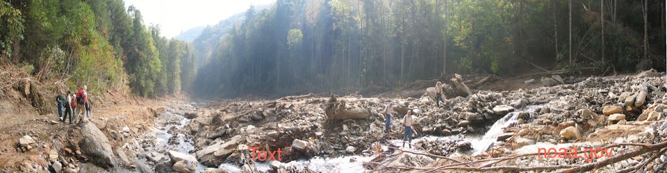
Oregon Inlet. The single largest allocation of new money ($15 million) would fund an effort to acquire federal lands surrounding Oregon Inlet and the erosion-threatened segment of N.C. Highway 12 on Hatteras Island. The lands targeted for acquisition now make up parts of Cape Hatteras National Seashore and Pea Island National Wildlife Refuge. The newly acquired lands would be designated as a state park, but the special budget provision tied to the funding describes the purpose of the acquisition as managing “existing and future transportation corridors” on the Outer Banks. An earlier post describes the cost (as of 2013) of maintaining Highway 12 in the face of high erosion rates and inlet movement.
Continuing erosion and storm damage have made it increasingly difficult to maintain Hwy 12 within the original right of way. Going outside the right of way means working on federal lands. The National Park Service and federal wildlife refuge managers have worked with the state to reach agreement on a number of previous Hwy 12 maintenance and relocation projects, but conditions have now deteriorated to the point that future projects could involve much more significant impacts to lands in the national seashore and wildlife refuge. Some of the proposed maintenance and relocation options for Hwy 12 also conflict with the conservation purposes of the federal lands. Management plans for national seashore and wildlife refuge give high priority to maintaining a natural, unobstructed shoreline and protecting wildlife habitat.
The bill directs the state Department of Administration to begin negotiating an agreement to acquire the federal lands by purchase or exchange of state land for federal land. If efforts to negotiate an agreement fail, the bill directs the department to begin efforts to acquire the lands by condemnation next year, Not surprisingly, the budget provision allows use of some of the funding for litigation expenses. The budget cobbles together the $15 million allocation by transferring a total of $7 million from two specific DENR fund accounts ($3.5 miilion from each); appropriating $5 million in new money; and earmarking an additional $3 million in capital reserves. One of the two DENR fund accounts appears to be a Marine Fisheries fund for license revenue; the budget provision identifies the fund by number and title (the “Advanced License Sales Fund”).
The bill also has language (similar to a provision in the Senate regulatory reform bill) authorizing the Governor to waive state coastal development permits and environmental impact statements for projects needed to maintain transportation access to Hatteras Island. As noted in an earlier post, waiver of state environmental review may not actually shorten the permitting process –the Governor’s action cannot affect federal permits needed for the Hwy 12 projects and the state and federal permit reviews have been coordinated for many years to streamline review. On the other hand, waiving state permits for the project will remove any influence the state might otherwise have on the federal permitting process — taking state environmental permitting staff out of the negotiation entirely,
Coal Ash. The Senate has proposed to appropriate $1.75 million to DENR to support activities related to regulation of coal ash, including 23 new staff positions. The staff positions would be allocated among the Division of Energy, Mineral and Land Resources (7 total positions – 2 in stormwater and 5 in dam safety); Division of Waste Management (2 positions); Division of Water Resources (8 positions) and the DENR Secretary’s Office (6 positions). Funding is contingent on passage of Senate Bill 725 (Governor’s Coal Ash Management Act) or similar legislation,
Shale Gas. The Senate budget appropriates an additional $1.17 million dollars for shale gas activities. Most of the funding ($973,324) would be used for additional geological and geophysical analysis of the shale basins in the state. The remaining funds have been identified for marketing and promoting the state’s shale gas resources ($100,000); digitizing data ($50,000); and doing more chemical analysis of gas wells ($50,000).
Transferring Interest Income from DENR Special Funds. DENR has a number of interest-bearing special funds. Some were created to provide a source of revenue for conservation programs; others receive a combination of fees and tax revenues to fund cleanup of environmental contamination. The Senate budget would transfer all of the interest earned by these funds to the state’s General Fund, reducing the funds available for the originally intended purpose and allowing the legislature to reallocate the interest income for other uses. The conservation funds affected include the Clean Water Management Trust Fund; the Marine and Estuarine Resources Conservation Fund; the Ecosystem Restoration Fund; the Parks and Recreation Trust Fund; and the N.C. Marine Resource Fund.
The environmental cleanup funds affected by the transfer of interest income include the Dry-Cleaning Solvent Cleanup Fund; the Commercial Underground Storage Tank Fund; the Non-Commercial Underground Storage Tank Fund; the Inactive Hazardous Sites Fund; the Bernard Allen Emergency Drinking Water Fund; and a fund supporting the state Brownfields program for redevelopment of contaminated sites. Some of the special funds receive revenue from fees and taxes imposed on a particular commercial activity (such as dry-cleaning and operation of petroleum underground storage tanks) to address contamination associated with the activity. The proposed transfer would allow use of the interest income on those fees and taxes for unrelated purposes.
The state Brownfields program (which assists in the redevelopment of contaminated sites) operates entirely on federal funds and fees paid by the prospective developers. The program receives no state appropriations, so the special fund provides the only source of operating funds. A number of the environmental cleanup funds (including the Commercial UST Fund) have been chronically underfunded and transfer of the interest income will only further reduce the resources available for assessment and cleanup of contamination.
Marine Fisheries. It is hard to find a plan behind the many changes to the marine fisheries budget. The bill increases a significant number of commercial and recreational fishing license fees and fees for fish dealers, while slightly reducing fees for commercial fishing vessels. The budget reduces funding for fisheries conservation by transferring interest income from several special funds to the General Fund and transferring $3.5 million from one license fee fund account to a fund to acquire property on the Outer Banks. At the same time, the bill eliminates appropriations for the At-Sea Observers program (necessary under a state-federal agreement keep some N.C. fisheries open by monitoring the impact on endangered sea turtles) and shifts the costs of the program to license fee revenue. The bill also directs a portion of the higher commercial fishing fees to a new Commercial Fisheries Resource Fund. The result of all of the moving pieces seems to be higher fees, reduced appropriations, and at the same time a transfer of fisheries fee revenue to other purposes.