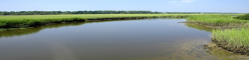
Highway 12 extends from mainland Dare County south across Oregon Inlet (by way of the Bonner Bridge) to Hatteras Island. The road travels through Cape Hatteras National Seashore and Pea Island National Wildlife Refuse before reaching the Village of Rodanthe at the southern end of the island. At several points, the island narrows to a ribbon between the Atlantic Ocean and brackish ponds in the wildlife refuge.
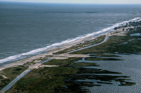
Photo credit: County of Dare / Foter.com / CC BY-NC-SA
For decades, the state has cleared, relocated, rebuilt and repalred storm-damaged sections of the Hatteras Island highway. On March 19 2013, N.C. Gov. Pat McCrory issued an executive order again declaring a state of emergency for N.C. Highway 12 to allow use of state and federal emergency funds to repair Hurricane Sandy damage on Hatteras. Repair costs for the most recent damage have been estimated at $8-10 million.
In 2010, the state made a commitment to perpetually maintain Highway 12 as the main transportation link to Hatteras Island — without assurance that it is technically possible and without knowing the cost. The commitment was sealed when the N.C. Department of Transportation (NCDOT) decided to replace the aging Bonner Bridge over Oregon Inlet with a new bridge built in a parallel location. Bonner Bridge carries Highway 12 from mainland Dare County across Oregon Inlet to Hatteras Island; unless Highway 12 continues south on Hatteras Island, traffic coming off the new Bonner Bridge will have nowhere to go.
In making the Bonner Bridge replacement decision, NCDOT looked at a number of other alternatives — including a sound-side bridge that would connect to Hatteras Island at the island’s midpoint (rather than bringing traffic directly south from Nags Head) and expanded ferry service in place of a bridge. NCDOT cited a number of reasons for choosing a new Oregon Inlet bridge and maintenance of Highway 12 as the preferred transportation access to Hatteras Island — including the high cost of a sound-side bridge. But it is also clear that Dare County citizens and local government officials pushed for continued road access from mainland Dare County to Hatteras Island.
As the state was deciding to go all in to continue the historic road access to Hatteras Island, a combination of storm damage and shoreline erosion was making it increasingly difficult — and expensive — to keep Highway 12 open. In 2003, Hurricane Isabel breached Hatteras Island – creating a small inlet connecting the Atlantic Ocean to the waters of Pamlico Sound behind the island. NCDOT filled the Hurricane Isabel breach, but when the area breached again in 2011 NCDOT built a temporary bridge over the new inlet. The storm that reopened the Isabel breach, Hurricane Irene, also opened a second breach to the south. The most recent damage occurred in October of 2012 when Hurricane Sandy overwashed the temporary bridge and caused the highway to buckle and overwash in several places south of the temporary bridge.
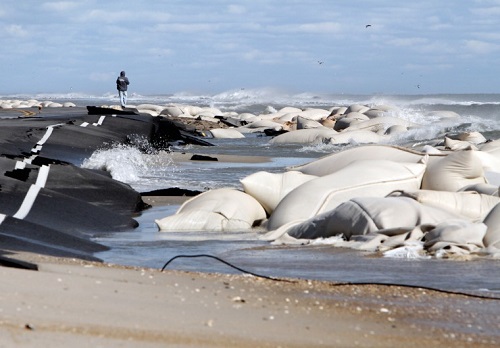
Highway 12 at Mirlo Beach (October 2012). Photo: The Virginian Pilot.
The Cost
In the last 25 years, the state has spent over $23 million (in state and federal funds) to repair the most threatened sections of Highway 12 on Hatteras Island. That figure does not include the additional $8-10 million needed to repair the October 2012 Hurricane Sandy damage. (WRAL News has compiled a 25-year history of repair costs for the Hatteras Island sections of Highway 12 from information provided by NCDOT.) The raw numbers don’t tell the whole story – the highway has experienced catastrophic storm damage at an accelerating pace in the last few years. Of the $23 million spent since 1987, 75% was spent in the last 10 years.

5-year costs in thousands of dollars.
The chart shows Highway 12 repair costs for each five-year period since 1987. It does not include the costs of repairing the 2012 Hurricane Sandy damage; the most conservative estimate of Sandy repair costs ($8 million) would bring total repair costs since August of 2011 to more than $20 million. The costs also don’t include long-term work needed to keep Highway 12 open as the Hatteras Island shoreline continues to change. NCDOT has identified a number of erosion “hotspots” and possible breach locations along the 12.5 mile section of highway between the Bonner Bridge landing and Rodanthe. The options under study include permanently bridging the most threatened sections of the highway within its existing right of way. That approach could put bridged sections of Highway 12 hundreds of feet offshore within a few years as the island itself continues to erode and migrate toward the mainland.
Replacing Bonner Bridge has been estimated to cost between $265 and $315 million (in 2006 dollars). When you add the cost of addressing the erosion hotspots and areas at risk of breaching on Highway 12 south of the Bonner Bridge landing , the total cost of maintaining road access from the Dare County mainland to Rodanthe may be as high as $1.5 billion (also in 2006 dollars). The actual costs are unknown; the final NCDOT/ Federal Highway Administration decision documents for the Bonner Bridge replacement project left specific decisions about how to stabilize Highway 12 on Hatteras Island to be made in the future.
Right now, it all has the feel of decision-making avoided. Inertia will carry the state along a path of maintaining a highway in the sea unless state leaders look again at the most basic questions:
1. What is the purpose of Highway 12 on Hatteras Island — to provide safe access on and off the island or to maintain a road from mainland Dare County to Hatteras Island? The two are not the same.
2. Can the state — at any reasonable cost — maintain Highway 12 between Oregon Inlet and Rodanthe as the Hatteras Island shoreline continues to erode and migrate toward the mainland?
3. Is there another way to provide transportation access on and off the island that can more easily adapt as the Hatteras Island shoreline changes?
The NCDOT decision to replace the Bonner Bridge in a parallel location and permanently maintain Highway 12 on Hatteras Island has been appealed by two wildlife organizations. That appeal is pending in federal district court. NCDOT’s evaluation of options for maintaining Highway 12 on Hatteras Island is ongoing.