
April 7, 2014. The recent mudslide in Oregon that killed at least 30 people occurred in an area with a history of slides extending back to the 1940’s. A series of studies, including a 1999 U.S. Army Corps of Engineers report, warned of the potential for catastrophic failure of the slope. After receiving another report on the landslide risk from private consultants in 2004, Snohomish County considered creating a program to buyout homes in the area at greatest risk. In the end, the county chose to do a slope stabilization project instead. (See this Seattle Times article for a history of the Oregon slide area.)
The Oregon disaster has raised (again) questions about landslide risk and the role of state and local government in responding to those risks. The questions about availability of landslide hazard information; communication of risk to property owners and homebuyers; and the need for regulation of development on steep slopes have very recent echoes in North Carolina policy debates.
North Carolina can have hundreds of landslides a year — most in the mountainous western part of the state. According to this report by WSPA news, the N.C. Geological Survey estimated 300 landslides, rock slides and slope failures in 2013. Slides in uninhabited areas may do little damage, but the state also has a history of large, dangerous landslides causing millions of dollars in property damage and a number of deaths. Rock slides periodically close interstate highways and sections of the Blue Ridge Parkway, impeding transportation in western counties for months and requiring costly repairs.
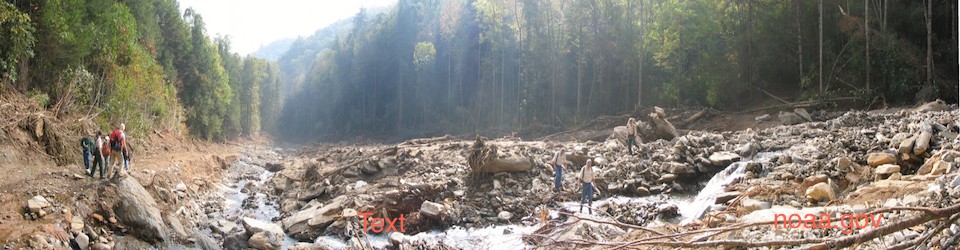
Panoramic photo of 2004 Peeks Creek landslide, Macon County, N.C. (noaa.gov)
In 2004, the state experienced over 100 landslides triggered by just two heavy rainfall events associated with back-to-back hurricanes (Frances and Ivan). In September 2004, a slope failure following Hurricane Frances destroyed one home in a subdivision near Boone and caused eight others to be condemned for occupancy. The same storm caused a slope failure and debris flow that destroyed a home in Burke County and left a home in McDowell County on the edge of an eroded slope. A week after Frances, Hurricane Ivan rainfall caused slope failures and debris flows that destroyed homes in Buncombe and Macon counties. The Macon County event (known as the Peeks Creek landslide) began near the top of Fishhawk Mountain and barreled 2.25 miles down the mountain at an estimated 30 miles an hour. The Peeks Creek disaster destroyed fifteen homes, killed five people and injured two others. The event also caused state and local officials to take steps toward identifying landslide risk for the first time.
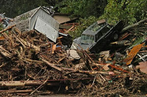
Photo of Peeks Creek slide damage (N.C. Dept. of Public Safety)
For more information on the Peeks Creek disaster, see the N.C. Geological Survey report and an analysis by the National Oceanic and Atmospheric Administration.
After the Peeks Creek slide, the N.C. General Assembly earmarked funds from the 2005 Hurricane Recovery Act to start a state landslide hazard mapping program focused on 19 western counties. Five N.C. Geological Survey employees began mapping landslide hazard areas in the counties considered to have the greatest landslide risk. By 2010, state geologists had completed landslide hazard maps for four counties (Macon, Henderson, Watauga and Buncombe), using information on historic landslide locations, soil types and slope data. The maps can be accessed through links on the N.C. Geological Survey homepage.
As state geologists worked on the first landslide hazard maps, the N.C. General Assembly considered several bills to address development on steep slopes. The 2007 Safe Artificial Slope Construction Act (House Bill 1756) would have required local governments to set standards for development on artificially-created steep slopes. The bill also proposed to amend real estate disclosure laws to require notice to a prospective purchaser of location in a landslide hazard area identified on N.C. Geological Survey maps. The bill encountered resistance from some mountain-area local governments as well as realtors and developers and never got out of committee. A 2009 bill (also titled the Safe Artificial Slope Construction Act) took a step back and simply proposed a legislative study committee to look at the need for statewide artificial slope construction standards and disclosure of natural landslide hazards to prospective purchasers. The 2009 bill also failed to get out of committee.
Against this background of resistance to state action on steep slope construction standards and disclosure of natural landslide hazards, the 2011 General Assembly defunded the landslide hazard mapping program. The budget cut eliminated four of the five landslide hazard mapping positions and brought state mapping efforts to an end.
As the state backed away from any role on landslide hazard mitigation, some local governments in the western part of the state (including Macon County) moved ahead with ordinances on steep slope development. A few of the 15 counties the N.C. Geological Survey mapping program did not reach have attempted to map landslide hazard areas using other funding sources.
The state has returned to the more limited role of emergency response and disaster relief. Basic property insurance does not cover landslide damage. In the 2005 Hurricane Relief Act, the N.C. General Assembly allocated over $200 million in state funds for disaster relief largely focused on western counties that experienced flooding and landslide damage from Frances and Ivan. Uses of the disaster relief funds included “housing buyout and relocation assistance for those persons whose homes were destroyed or severely damaged by debris flows or whose homes are located in a landslide zone”.