Category Archives: Coastal Development

The Disappearance of the Coastal Resources Commission

September 25, 2013.   Under the state’s Coastal Area Management Act (CAMA), the Coastal Resources Commission (CRC) has responsibility for developing standards needed to balance protection of highly productive  coastal resources, public trust rights, and  economic development.  But  the N.C. Coastal Federation’s Coastal Review Online  reports that  the CRC  has been effectively out of commission since the beginning of August. The question is why.

This year,  the General Assembly  changed the makeup of the  Coastal Resources Commission by  reducing the number of commissioners from 15 to 13;  revising  the categories for appointment; and  giving  legislative leadership the  power  to appoint 4 of the 13 members. (See Sec. 14.24  of Senate Bill 402.) To  make the changes  effective more quickly, the  bill  caused the terms of  all  Coastal Resources Commission members serving on January 1, 2013 to  expire on  July 31, 2013 with four exceptions. Those four seats, specifically identified in the bill, have terms expiring on June 30, 2014. The bill required  the Governor to appoint nine new CRC members by August 1, 2013 to replace the nine whose  terms would end on July 31, 2013.

The problem is that  new appointments have not been made and the CRC webpage now lists only four members  — the four whose terms extend until June 30, 2014.  Those four members alone  participated in a special called meeting of the commission  in August to make a decision  related to litigation over an earlier CRC  variance decision. The regular September  meeting of the CRC scheduled for this week has been canceled.

The reason for the sudden loss of two-thirds of the commissioners  is unclear.  Both the N.C. Constitution and state law  expressly say that state officials can and should serve  until their successor has been appointed or elected.

N.C. Constitution, Article VI, Sec. 10: “In the absence of any contrary provision, all officers in this State, whether appointed or elected, shall hold their positions until other appointments are made or, if the offices are elective, until their successors are chosen and qualified.”

N.C.G.S. § 128-7: “All officers shall continue in their respective offices until their successors are elected or appointed, and duly qualified.”

The term “officers” covers all elected and appointed state officials, including members of boards and commissions. The provisions exist to guarantee that essential government functions continue even as terms of office end.   N.C. judges  have applied  the provisions to find that decisions made by state officials  beyond the end of their appointed term are valid  and enforceable since  those officials legitimately continue in  office until a  successor takes over.

The CRC’s responsibilities go beyond  rule adoption. CAMA also gives the CRC power to grant variances from  coastal development  standards,  issue declaratory rulings (interpreting how  coastal development rules  apply to a particular project), and approve local land use plans in the coastal counties. Those decisions are often time sensitive and important to developers as well as local governments,  community groups and environmental organizations. Right now, the CRC cannot meet those obligations with a membership of four.   Four commissioners may not even  meet CRC quorum requirements unless the remaining nine members resigned or have been individually removed from office. (Neither seems to be the case.)  The remaining four commissioners also cannot represent the broad range of interests and expertise needed to make balanced decisions about protection of the state’s coastal resources.

Coastal Policy: Messages from Hurricane Sandy

August 27, 2013.  Just in time for the most active hurricane months, a look at Hurricane Sandy recovery:

Rebuilding.   New Jersey   will use  $250 million in federal Sandy disaster relief funds to buy out as many as 1,000 homes in communities like those along the South River and Raritan Bay that have flooded with increasing frequency.  The program aims to buyout entire streets and blocks of buildings in  high risk areas.  This is not a new use of federal disaster relief  funds;  similar buyout programs have been used to remove structures from floodplains in other parts of the U.S. after repeated flood events.

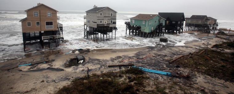
The story on the beaches is different. Both New York and New Jersey opted for quick rebuilding in the beach communities.  Shoreline changes  may have made  reconstruction physically impossible on some beach properties,  but otherwise the  two states decided  to allow beach communities to rebuild basically as they were before the storm. The emphasis on  quick reconstruction overwhelmed any discussion of policy changes  that might lessen damage in future storms.    Even with the push to rebuild, residents of N.Y. and N.J. beach communities have experienced  delays for all of the usual reasons: the need to  cleanup and  restore  basic  public infrastructure;  a wait for insurance payouts;  the need  for additional financing when insurance payouts  fell short; the slow realization that some houses still upright after  Sandy will have to be bulldozed  because of extensive  water damage; and the additional cost of elevating homes to meet federal flood insurance standards.

More on new federal  flood insurance maps and the cost of elevating structures;  beach nourishment projects; and  conflicts over reconstruction (and expansion) of seawalls on the New York and New Jersey oceanfront  below.

Revised FEMA Flood Maps.  The Federal Emergency Management Agency (FEMA) started the 3-5 year process of updating flood insurance rate maps (FIRMs) for  eastern seaboard states before Hurricane Sandy. The maps, which designate high hazard flood zones for purposes of the federal flood insurance program,  had last been updated in the 1980s. A lot has changed since then;  the United States Geological Survey estimates that sea level rise  along the New Jersey coast has risen between 6 and 9 inches  in the last 50  years and stormwater runoff from increased development also contributes to higher flood risk.  FEMA planned to finalize  updated  flood maps for New Jersey and New York in the second half of 2013,   but  issued “advisory” maps in December of 2012 to help property owners make rebuilding decisions after Sandy.

As expected, the new FEMA maps had  larger flood hazard areas, including larger  V-zones; these are areas likely to flood as a result of wave action (“V”  stands for velocity)  where structures require higher and more expensive elevation.   Federal flood insurance standards require structures located in certain high hazard flood zones, such as  V-zones and A-zones (the designation for many coastal areas just landward of the V-zones)   to be elevated above base flood elevation or  pay much higher federal flood insurance premiums. New structures and those  more than 50% damaged must be elevated above the new base flood elevation to  be insured  at all. Elevation can add tens of thousands of dollars in cost; the amount depends on the required height and method used to raise the house.

Shortly before Sandy,  Congress amended  federal flood insurance laws to make the program more financially stable. The Biggert-Waters Flood Insurance Reform Act of 2012 directed FEMA to make flood insurance rates  reflect flood risk and phase out  insurance subsidies for  homes built before the first federal flood insurance  rate maps were adopted in 1975. You can find more information on 2012 changes to the federal flood insurance program here.  The prospect of higher flood insurance rates, elevation of additional homes (including homes predating the flood insurance program) and a major east coast hurricane created a perfect storm of confusion and anxiety.

The larger V-zones shown on the advisory maps  generated a Stop FEMA Now movement  by property owners  concerned about  the cost of elevating their homes  and  higher flood insurance rates.   New Jersey Gov. Chris Christie urged beach communities to take advantage of the FIRM revision process  to provide  FEMA with information to  support  smaller  flood hazard zones. By June of 2013,  FEMA had  modified draft  maps for the New Jersey shoreline. Although the June maps still expand flood hazard areas, FEMA reduced the size of   many of the V-zones  shown on earlier advisory maps. FEMA expects to finalize maps and new flood insurance rates  in 2014. In the meantime, the uncertainty about flood hazard designations and elevation requirements caused some homeowners to delay rebuilding.

Note:   The  1980’s-era flood insurance rate maps for N.C. have already been updated thanks to a cooperative effort between the state and FEMA.  In 1999, North Carolina  experienced  the problem of out-of-date flood hazard maps when  Hurricane Floyd caused devastating and unexpected  flooding along coastal rivers and streams. In response, the N.C. General Assembly  created and funded  the N.C. Floodplain Mapping Program. The new state program took on  the technical work needed to update the FIRMs for N.C. under a cooperative agreement with FEMA    By 2008, the first phase of map updates (covering the six coastal river basins)  had been completed and adopted for use in the federal flood insurance program.  As in  N.J.,   more recent N.C. data  confirmed the practical experience of Hurricane Floyd —  because of sea level rise and increased stormwater runoff, larger areas are vulnerable to significant flooding.

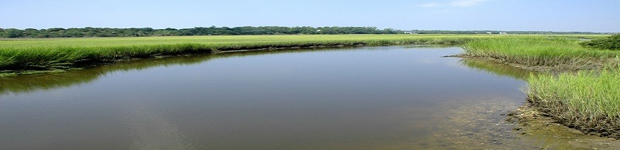
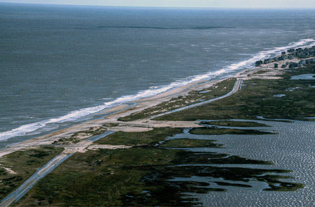
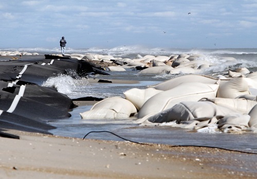
Beach Nourishment. In New Jersey,  Hurricane  Sandy  response  means  major beach nourishment and dune construction projects to rebuild eroded beaches. Communities that   had nourished beaches before Sandy clearly fared  better than those  that did not.  Although Sandy  eroded  the   nourished  beaches,  the protective  dunes took the brunt of the storm rather than the oceanfront development behind the dune line.  New Jersey has proposed to rebuild  protective dunes that  existed before Sandy and extend dune construction to additional communities.     The challenges: money,  easements and sand (in shorter supply than many people assume).

Money

Dr. Stewart Farrell and colleagues in the Coastal Research Center at  Stockton College of New Jersey estimate  that between 1985 and 2008 New Jersey beaches received  80 million cubic yards of sand  at a cost of  $800 million (not adjusted for inflation).  The larger beach  nourishment projects  were built by the U.S. Army Corps of Engineers  under a cost-sharing formula with the state. Under the  current  cost sharing formula, federal funds pay   65%  of the cost  for  an authorized federal  “hurricane protection” project to  nourish a beach and build protective dunes; the remainder of the cost is  shared by state and local government.   This year, Congress allocated $5.4 billion to the Corps of Engineers for Hurricane Sandy response.  See  “The Beach Builders” by John Seabrook in the July 22, 2013 issue of The New Yorker magazine for the past and present of beach nourishment on the New Jersey shoreline.

Not surprisingly, the high cost of beach nourishment  periodically causes both Presidents and members of Congress to question the wisdom of investing federal money in projects designed to erode away.  Both Presidents Clinton and George W. Bush attempted to either eliminate or scale back federal funding for beach nourishment.  Pressure to protect valuable real estate, expensive homes and tourism revenue won out.

Easements

The landward edge of a  beach nourishment/dune construction project has to be anchored above the mean high water line — which most often means on private property. For federally funded projects, the U.S. Army Corps of Engineers requires an easement for construction from each private property owner affected and puts the responsibility for acquiring the easements on the local government.  Beach towns ( even before Sandy) have sometimes met resistance from  property owners for a variety of reasons —  most often, fear that the easement will  allow public use of their property.  New Jersey’s goal is to  build continuous lines of protective dunes in  Ocean County, Cape May and Atlantic County beach communities.  Easement acquisition has been slow; according to a recent local news story  only half of  the easements needed for the N.J. beach projects have been granted by oceanfront property owners.   (Gov. Christie has made his feelings about that  known.)

Although a local government can use the power of eminent domain to condemn  easements for beach nourishment,   an eminent domain case  related to  an earlier   dune construction   project in  the Borough of Harvey Cedars, N.J. cast a shadow over post-Sandy easement acquisition until very recently.    Harvey and Phyllis Karan opposed construction of the 22-foot storm protection dune in  Harvey Cedars because  it would block the   view from the first floor of their oceanfront house.  The Karans refused to grant an easement for the project and after the Borough acquired an easement on the Karan property by eminent domain in early 2009, the issue of compensation for the easement ended up in court.  The Borough offered the Karans a small amount ($300) to compensate for the impact on their  view; the Karans’ lawsuit asked for $500,000, arguing that construction of the dune (which was completed in 2010) reduced the value of their $1.9 million house by 25%.

When the compensation case went to trial, the judge did not allow the jury to consider any benefit to the Karans from construction of the 22-foot dune. The jury awarded the Karans $375,000 in compensation.  Hurricane Sandy came through while the  Borough’s appeal was pending in the N.J. Supreme Court  —  eroding the dune, but leaving the Karan home largely undamaged.  Hurricane Sandy may well have affected the outcome of the  case by so dramatically supporting the Borough’s argument that the dune project benefited the Karan property.  In July, the New Jersey Supreme Court issued a decision in  Borough of Harvey Cedars v. Karan, 425 N.J. Super. 155 (App. Div. 2012), rev’d and rem’d, ___ N.J. ___ (2013),  reversing the condemnation award   and sending the case back down for a new trial, saying in part:

“The trial court’s charge required the jury to disregard even quantifiable storm-protection benefits resulting from the public project that increased the fair market value of the Karans’ property… [T]he quantifiable decrease in the value of their property — loss of view — should have been set off by any quantifiable increase in its value — storm-protection benefits. The Karans are entitled to just compensation, a reasonable calculation of any decrease in the fair market value of their property after the taking. They are not entitled to more, and certainly not a windfall at the public’s expense.”

You can find the  entire opinion  here.

N. J. officials clearly hope that the Karan decision will persuade more oceanfront property owners to grant easements for the shore protection projects rather than hold out for large compensation awards.

Seawalls, Revetments and Groins (Oh my!).  Duke University geologist Orrin Pilkey  has often used the New Jersey shoreline as the  living illustration of  the damaging effects of seawalls, revetments and groins on ocean beaches– loss of the recreational beach,  obstruction of public access, and increased erosion on  nearby properties.  Pilkey  made “New Jerseyization” the description of  a choice to sacrifice the beach to use of engineered structures to protect buildings. (You can find a good introduction to the  different types of erosion control structures on  the Surfrider Foundation’s   Beachapedia website. The Surfrider Foundation has opinions on the subject, but the descriptions and illustrations are straightforward and factual. )

Both New York and  New Jersey  have permitted construction of oceanfront erosion control structures to protect public and private property.  Based on the rules currently in place, New York seems to have fewer restrictions.  On paper  (sometime practical application looks different), New York coastal policies appear to tilt in favor of permitting an erosion control structure unless it would affect particularly sensitive natural resources such as wetlands.     Unlike New Jersey,  New York does not require an applicant for a  seawall permit to first show that other approaches will not work.  New Jersey rules seem to reflect greater skepticism about use of erosion control structures on the ocean beach.  In terms of publicly funded beach protection projects, New Jersey  has  focused on beach nourishment as the preferred public response to  post-Sandy shoreline erosion.

Both states have  dealt with post-Sandy controversies related to oceanfront seawalls.  Before Hurricane Sandy, Ocean City (N.J.) had a seawall made up of boulders 18 feet high. After the hurricane, Ocean City rebuilt and extended the seawall   to the boundary with the adjacent town of Matoloking.  Matoloking, which lost about 150 feet of beach in Hurricane Sandy,  sees the extended seawall as a threat to the beach nourishment and dune construction project in Matoloking –potentially  increasing erosion of the protective  dunes Matoloking hopes to build.

In Southhampton N.Y., billionaire hedge fund managers built sheet steel and rock barriers oceanward of their homes under permits  to replace or repair structures that existed before Hurricane Sandy.  Fast track permits issued by the N.Y. Department of Environmental Protection allowed the property owners to  build structures larger than those that existed before Sandy, but without notice to neighbors or the local government. A New York Times  story described one of the new structures as being built with boulders the size of Volkswagons.   Surprised  local officials have expressed  concern about the impact of these large structures on the beach, as waves reflect off the structures and increase beach erosion.

Although the tide seems to have  turned  against use of seawalls, groins and revetments on the oceanfront in recent years, past decisions to permit  those kinds of  structures still echo through the Sandy recovery.

Legislative Wrap-Up V: Miscellaneous

August 14, 2013. Bits and pieces of environmental legislation (air quality, coastal development, sedimentation, renewable fuels tax credit). Many of the provisions discussed below were adopted as part of House Bill 74 (Regulatory Reform Act of 2013), which the Governor has not yet signed into law. The Governor has until August 25th to sign or veto  a bill adopted at the end of the legislative session; if the Governor takes no action, the bill becomes law without his signature.

Appeals of  Air Quality and Water Quality Permits

House Bill 74 (Regulatory Reform Act of 2013) includes two separate provisions that shorten the time for a third party  to appeal an air quality or water quality permit from 60 days to 30 days. (See Section 29 and Section 53.) The time for an applicant to appeal a permit decision has always been 30 days, but a third party (such as  a neighbor, local government or community organization) fell under the  60-day appeal period set in the state’s Administrative Procedures Act . The challenge for third parties is that the appeal period begins to run when the applicant gets notice of the permit decision — not when the third party receives notice.

Air Quality

Local Transportation Mitigation Ordinances.  House Bill 74 ( Regulatory Reform Act)  prohibits local governments from  using a fine or penalty to enforce  certain types of ordinances to reduce the air quality impacts of commuting by car. Section 10.1(a) of the bill adds a new statute section, G.S. 160A-204  (entitled Transportation impact mItigation ordinances prohibited):

“No city may enact or enforce an ordinance, rule, or regulation that  requires an employer to   assume financial, legal, or other responsibility for of the impact of his or her employees’ commute or transportation to or from the employer’s workplace , which may result in the employer being subject to a fine, fee, or other monetary, legal, or negative consequences.”

Section 10.1(b) adds a new G.S. 153A-145.1 that applies the same prohibition to counties.  A  Durham  ordinance requiring large employers to have a plan to reduce commuter miles traveled by employees may be an example of the kind of ordinance the legislation would  affect. The Durham ordinance allows the employer to choose a number of different approaches to reduce commuting by car, including: work-at-home policies; incentives for car-pooling; creation of company van pools; and shower facilities for employees who bike to work.

There was little discussion of the provision as House Bill 74 moved toward adoption,  but the same language appeared in a different House bill titled  Local carbon footprint ordinances (House Bill 677). The  title suggests that lawmakers  linked transportation mitigation ordinances to climate change policy.  In reality, these ordinances mostly have to do with reducing ozone pollution to  meet federal air quality standards.  As much as 70% of the ozone pollution in urban areas comes from motor vehicle emissions and reducing vehicle miles traveled is one way to keep motor vehicle emissions down.  The Durham ordinance talks specifically about the need to reduce nitrogen oxide emissions that contribute to high ozone levels.  Many of the state’s urban areas will be hard-pressed to meet tighter federal air quality standards for ozone while continuing to grow. Failing to meet the ozone standard (“nonconformity” in Clean Air Act language) has significant economic consequences, including loss of federal highway funds and inability to permit new industrial development.  The language in House Bill 74 does not  eliminate the authority for these kinds of  ordinances,  but it  will  make the ordinances difficult to enforce and possibly reduce their effectiveness as a tool to maintain ozone  conformity  in the state’s major metropolitan areas.

Repeal of Heavy Duty Diesel Rules for 2008 and Later Vehicles. Section 25 of House Bill 74 directs the Environmental Management Commission to repeal rule 15A NCAC 02D.1009 (Model Year 2008 and Subsequent Model Year Heavy Duty  Vehicle Requirements) by December 1, 2013. The rule was adopted  by the Environmental Management Commission in 2004 and required model year 2008 and later heavy-duty diesel vehicles to meet California emissions standards. The U.S. Environmental Protection Agency has allowed California to adopt more strict motor vehicle emissions standards than those in federal rules and a number of states have adopted California standards by reference. The EMC adopted the California heavy duty diesel standard because lawsuits delayed the federal standard for several years.  With a final  federal standard  for heavy duty diesel engines in place,  the state rule has become unnecessary. (The final  federal  standard turned out to be  nearly identical to the California standard that the EMC adopted by reference in 2004.)

Open Burning.  Section 28 of House Bill 74 makes a significant change to rules for open burning. Until now, open burning for land-clearing or right of way maintenance has only been allowed on the site being cleared unless the debris was taken to be burned in an air curtain burner,  (Air curtain burners or “fireboxes” provide better control of  smoke and particulate pollution than open burning of woody debris.) The new provision allows land-clearing debris to be transported off-site for open burning and allows that burn site to be used  up to  four times a year. The bill  requires an off-premises open burn to maintain the same setback distance from occupied structures as an  on-site open burn — 500 feet.  The impact on  nearby residents and building occupants may be different, however, if  the off-premises open burn site is used  more often.  The bill also exempts these off-site open burning locations from requirements that would otherwise apply to waste disposal site for land-clearing debris.

Air Quality Permit Terms. Section 29 of House Bill 74 sets the permit term for  most state-issued air quality permits  at eight years.   The term for  an air quality permit issued under Title V of the Clean Air Act  continues to be no more than  five years as required by federal law.

Coastal Development

Ocean and Inlet Erosion Control.  For over thirty years, state coastal policies  generally barred use of hard erosion control structures (like seawalls, jetties and groins) on ocean and inlet shorelines.  In  2011, Session Law 2011-387  made the first significant change in that policy by authorizing  DENR to permit  a limited number of   “terminal groins” under strict conditions.  A terminal groin is an erosion control structure built perpendicular to the shoreline and at the end of a section of beach. Terminal groins are sometimes used to stabilize an inlet shoreline. This year, Senate Bill 151  made several changes to the 2011 law. One of the most significant is a change in the definition of  ”terminal groin” to include projects that involve installation of “one or more” groin structures  or a single groin with  ”a number of smaller supporting structures”.

Although Senate Bill 151 keeps the 2011 limit on the total number of terminal groin projects permitted coast-wide (four), the new definition of “terminal groin” no longer matches the definition used by the U.S. Army Corps of Engineers. Expanding the term to include multiple groins as part of a single project means the law potentially authorizes projects well beyond the scope of a “terminal groin”. Senate Bill 151 also makes it easier  to get a terminal groin  permit by eliminating the need for the applicant to show that: 1.  the project is necessary to protect imminently threatened structures;  and 2. other shoreline stabilization measures  would not be successful. More background on the terminal groin issue and S.L. 2011-387 can be found here.

Local Authority in Public Trust Areas. Another section of Senate Bill 151 clarifies  local government authority to address nuisance conditions on the beach and prevent (or remove) obstructions in public trust areas of the beach. The clarification became necessary because of  a N.C. Court of Appeals decision in Town of Nags Head v. Cherry  that held only the state can take action to  remove a structure on the public trust beach. See an earlier post for background on the Nags Head case.

Notice of CAMA Minor Development Permits.  Section 30 of House Bill 74 eliminates the requirement for newspaper notice of Coastal Area Management Act (CAMA) minor development permits. Notice will still be provided to any person or organization requesting notice of permit applications and by posting a notice at the site of the proposed development. Note: Under CAMA, “minor development”   can still be a significant  construction project.   CAMA  defines “major development”  to include any project that  requires another state or federal approval; occupies an  area of more than 20 acres; involves drilling for or excavating natural resources; or  occupies a structure(s) with a footprint of 60,000 square feet or more. All other development projects are considered “minor development”. As a practical matter, most projects that disturb an acre or  more will be “major development” because of the need for a sedimentation plan approval.

Note: As of  now, Senate Bill 151 has not been signed by the Governor and so has not yet become law.

Sedimentation Act

Local Sediment Programs. The Sedimentation Pollution Control Act  allows  DENR to delegate enforcement of the law to approved local sedimentation programs and many cities and counties have local programs. Section 33 of House Bill 74 resolves a recent question about  the role of the state’s Office of Administrative Hearings (OAH) in appeal of a civil  penalty assessed by a local program for violation of the Sedimentation Act. The bill makes it clear that those appeals  will be decided by the local government  under  the appeal process set out in the local sedimentation program ordinance. Appeals will not go to the Office of Administrative Hearings.

Tax Credit for Renewable Fuel Processing Facilities

House Bill 112 (Modifications to 2013 Appropriations Act)  extends  the tax credit available for facilities built to process renewable fuel. The sunset date for the renewable fuel processing tax credit, G.S. 105-229.16D,  had already been extended several times. Last year, the General Assembly extended the tax credit to facilities in service by January 1, 2014.  Section 11.2 of  House Bill 112 extends the tax credit to facilities in service by January 1, 2017 as along as the developer  signs a letter of commitment with the N.C. Secretary of Commerce by September 1, 2013 and begins construction by December 31, 2013.

A Beach Bill For The Governor

July 19, 2013: The Senate accepted House changes to Senate Bill 151 (Coastal Policy Reform Act of 2013), which means the bill now goes to the Governor. The bill does two things:

1. Changes  existing law on construction of terminal groins for inlet stabilization.  The most controversial part of the bill makes changes to state law on construction of groins to stabilize inlet shorelines. After prohibiting permanent erosion control structures on ocean and inlet shorelines for nearly 40 years, state policy changed in 2011 when the General Assembly amended the Coastal Area Management Act to allow construction of terminal groins at inlets. A terminal groin is a structure built perpendicular to the beach at an inlet or at the end of an island to stabilize the shoreline;  in some cases, the groin also  traps sand moving along the shore to build up the beach behind the groin.

The 2011 legislation, Session Law 2011-387,  followed a 2010 study of terminal groins by the state’s Coastal Resources Commission (CRC). After reviewing the impact of the small number of existing inlet groins in North Carolina and similar projects in other states, the CRC issued a report concluding that terminal groins can have both positive and negative impacts and should only be allowed under very strict conditions. You can find links to the final CRC report and recommendations here.  Because of concerns identified in the report,  S.L. 2011-387 only allowed  four groin projects to be permitted coast-wide  as something of a pilot project. No projects have been permitted  yet.

In the most significant change to the 2011 law,   Senate Bill 151  redefines  “terminal groin” to include projects that could be something else entirely — including a  field of multiple groins.   The new definition of “terminal groin” no longer matches the definition used by the U.S. Army Corps of Engineers  to describe that  particular type of shoreline stabilization project.  Senate Bill 151 changes the definition in state law to include projects involving installation of “one or more” groin structures  or a single groin with  “a number of smaller supporting structures”. The expanded scope of the definition means that the Department of Environment and Natural Resources could permit projects with even greater impacts  than a simple  terminal groin — impacts that were never considered in the 2010 Coastal Resources Commission study.

2. Provides clear authority for beach communities  to address debris, damaged structures, personal property  and other obstructions on the public trust beach. This part of the bill responds to a N.C. Court of Appeals decision in Town of Nags Head v. Cherry  that concluded only the state has the authority to order removal of  nuisance structures from the public trust beach.  An earlier post provides a  more complete  discussion of the  case. Coastal towns had always assumed that their authority to enforce local ordinances –including nuisance ordinances —  extended to the public trust beach (the area between the mean high tide line and the mean low tide line).  In fact, state law specifically recognizes local authority to regulate many activities on the public trust beach and the charters for some coastal towns extend into the water. The Court of Appeals decision, however,  made a distinction between ordinances generally and those specifically intended to protect public trust rights  and held that only the state could act to protect those rights. The bill returns the law to what many in both state and local government had always believed it to be — shared state and local authority to protect public rights of access to the beach and to address conditions that create a health and safety hazard on the beach.

Night of the Living Dead: Board and Commission Reorganization

In House Bill 1011 (Government Reform and Reorganization Act). the  boards and commission reorganization bill rises and walks again.  An earlier bill, Senate Bill 10,  died  when the House refused to adopt  compromise language negotiated with the Senate. The new bill came out of the House Rules Committee last week and quickly passed on the House floor.   Changes to the environmental commissions:

Coastal Resources Commission

— Reduces  the number of CRC members from  15 to 13;  nine members would be appointed by the Governor and  four by legislative leaders

— Eliminates  one at-large seat and the seat on the CRC currently designated for a representative of a  state or national conservation organization.

— Limits the number of CRC members who receive income from real estate development or construction. Seven of thirteen seats on the CRC  would have to be  filled by individuals “who do not derive any significant portion of their income from land development, construction, real estate sales, or lobbying and do not otherwise serve as agents for development related business activities”.

— Requires that all CRC  members be N.C. residents and either  reside or  own property in the coastal area

— Makes the transition to new appointees in two steps.  The bill would end the terms of all  CRC members  on June 30, 2013  with the exception of  the four members who have existing terms ending June 30, 2014.  Those four members are now in seats designated for commercial fishing,  wildlife or sports fishing, local government  and one of the three at-large seats.

Environmental Management Commission

—  Reduces  the number of EMC members to 15; nine members would be appointed by the Governor and six by legislative leadership.

— The bill keeps most of the categories for appointment to the EMC that appear in the existing statute (although in some cases, the number of EMC members in a given category may be reduced or categories have been combined). The bill eliminates the seat currently designated for a member  with public health experience and the seat for a member with experience in local government pollution control activities.

— The terms of all current EMC members would  end  on June 30, 2013. Eight new members will initially be appointed to two year terms and the remaining seven members to four year terms (to stagger the  terms). After the first set of new appointments, all members will be appointed to serve four-year terms.

The  bill also removes conflict of interest language in the EMC appointment statute. See N.C. General Statute 143B-283(c).  Both the Clean Air Act and the Clean Water Act   have conflict of interest standards  for members of state boards and commissions with  authority to issue federal permits. Under N.C. law, the EMC  has both air quality and water quality permitting authority. Although  the commission has delegated most permit decisions to DENR,  the EMC  still makes some permit and enforcement decisions (such as approval of major variances and civil penalty remissions requests.) To have  — and keep —  delegated permitting authority, North Carolina must meet the federal conflict of interest standards.  The sentence to be repealed closely tracks federal  Clean Air Act language requiring any state commission that approves permits or enforcement orders to have a majority of members who “represent the public interest and do not derive any significant portion of their income from persons subject to permits or enforcement orders under [the delegated air quality permitting program]”. An effort to amend the bill on the House floor to reinstate the conflict of interest language failed.

Wildlife Resources Commission

— Shortens the term for Governor’s appointees to the WRC from  six years to four years. (Members appointed on the recommendation of legislative leadership will continue to serve two-year terms.)

— The terms of all current WRC members would end on June 30, 2013.

— About one-half of the  Governor’s new appointees would be appointed to two-year terms and the remainder to four-year terms (to create staggered terms). After the initial appointments, all Governor’s appointees would be appointed to four-year terms.

The Highway and the Sea

Highway 12  extends from mainland Dare County south  across Oregon Inlet (by way of the Bonner Bridge) to Hatteras Island.    The road travels  through Cape Hatteras National Seashore and Pea Island National Wildlife Refuse before reaching the Village of  Rodanthe at the southern end of the island.    At  several points, the island narrows to a ribbon between the Atlantic Ocean and brackish ponds in the wildlife refuge.

Highway 12 to Hatteras aerial

Photo credit: County of Dare / Foter.com / CC BY-NC-SA

For decades, the state  has cleared, relocated, rebuilt and repalred storm-damaged sections of  the Hatteras Island highway. On March  19  2013, N.C. Gov. Pat McCrory issued an executive order  again declaring  a state of emergency  for  N.C. Highway 12 to allow use of state and federal emergency funds to repair Hurricane Sandy damage on Hatteras.  Repair costs for the most recent damage have been estimated at $8-10 million.

In 2010, the state  made  a commitment  to perpetually maintain Highway 12 as the main transportation link to Hatteras Island — without  assurance that it is technically possible and without  knowing the cost.  The commitment was  sealed   when the N.C. Department of Transportation (NCDOT)  decided  to replace the aging Bonner Bridge over Oregon Inlet  with a new bridge built in a parallel location.  Bonner Bridge carries Highway 12 from mainland Dare County across Oregon Inlet to Hatteras Island;  unless Highway 12  continues south on Hatteras Island,  traffic coming off the new  Bonner Bridge  will have nowhere to go.

In making the Bonner Bridge replacement decision, NCDOT looked at a number of other alternatives — including a sound-side bridge that would connect to Hatteras Island at the island’s midpoint (rather than bringing traffic directly south from Nags Head) and expanded ferry service in place of a bridge.   NCDOT cited a number of reasons for choosing  a new Oregon Inlet bridge and maintenance of Highway 12 as the preferred  transportation access to Hatteras Island —     including  the high cost of a sound-side bridge.  But it is also clear that  Dare County citizens  and local government officials   pushed  for continued road access from mainland Dare County to  Hatteras Island.

As  the state was deciding to go all in to  continue the historic road  access to Hatteras Island,  a combination of storm damage and shoreline erosion was  making it increasingly difficult — and expensive — to  keep  Highway 12 open.   In 2003, Hurricane Isabel breached Hatteras Island – creating a  small  inlet connecting the Atlantic Ocean to the waters of Pamlico Sound behind the island.  NCDOT  filled the Hurricane Isabel breach, but when the area breached again in  2011  NCDOT  built  a temporary bridge over the new inlet.   The storm that reopened the Isabel breach, Hurricane Irene, also opened  a second breach  to the south. The most recent damage occurred in October of 2012 when Hurricane Sandy overwashed the temporary bridge and  caused the highway to buckle and overwash  in  several places south of the temporary bridge.

Hwy 12_Oct 2012_Mirlo Beach

Highway 12 at Mirlo Beach (October 2012). Photo: The Virginian Pilot.

The Cost

In the last 25 years, the state has spent over $23 million (in state and federal funds) to repair the most threatened sections of Highway 12  on Hatteras Island.  That figure does not include  the  additional $8-10 million  needed to repair the October 2012 Hurricane Sandy damage.   (WRAL News  has compiled  a  25-year history of repair costs for the Hatteras Island sections of Highway 12  from information provided by NCDOT.)   The raw numbers don’t tell the whole story – the highway has experienced catastrophic  storm damage at an accelerating pace in the last few years.  Of the   $23 million spent since 1987, 75% was spent  in the last 10 years.

5-year costs in thousands of dollars.

The chart  shows Highway 12 repair costs for each five-year period since 1987. It does not include the costs of repairing the 2012 Hurricane Sandy damage; the most conservative estimate of Sandy repair costs ($8 million) would  bring  total  repair costs  since August of 2011 to more than $20 million. The costs also don’t include  long-term work needed to  keep  Highway 12 open  as the Hatteras Island shoreline continues to change. NCDOT has identified a number of erosion “hotspots” and possible breach locations  along the 12.5 mile section of highway between the Bonner Bridge landing and Rodanthe. The options under study include permanently  bridging the most threatened sections of the highway within its existing right of way. That approach could  put  bridged sections of Highway 12  hundreds of feet  offshore  within a few years as the island  itself continues to erode and migrate toward the mainland.

Replacing Bonner Bridge has been estimated to cost between $265 and $315 million (in 2006 dollars).  When you add the cost of  addressing the erosion hotspots and areas at risk of breaching  on Highway 12   south of  the  Bonner Bridge landing , the total cost of  maintaining road access from the Dare County mainland  to  Rodanthe  may be as high as $1.5 billion (also in 2006 dollars). The actual costs are unknown;  the final NCDOT/ Federal Highway Administration decision documents  for the Bonner Bridge  replacement  project  left  specific decisions about how to stabilize Highway 12 on Hatteras Island to be made in the future.

Right now, it all has the feel of decision-making avoided. Inertia will carry the state  along a path of  maintaining a highway in the sea  unless state leaders look again at the most basic questions:

1. What is the purpose of Highway 12 on Hatteras Island  — to provide safe access on and off the island or to maintain a  road from  mainland Dare County to Hatteras Island? The two are not  the same.

2. Can the state — at any reasonable cost — maintain   Highway 12 between Oregon Inlet and Rodanthe as the Hatteras Island shoreline continues to erode and migrate toward the mainland?

3. Is there another way to provide transportation access on and off the island that can more easily adapt as the Hatteras Island shoreline changes?

The NCDOT decision  to replace the Bonner Bridge in a  parallel location  and permanently maintain Highway 12 on Hatteras Island has been appealed by two wildlife organizations. That  appeal is pending in federal district court.  NCDOT’s evaluation of options for maintaining Highway 12 on Hatteras Island is ongoing.


Postcards from the Coast: Is that a septic tank on the beach?

The owner of [oceanfront] land loses title to such portions as are so worn or washed away or encroached upon by the water. Thus, the lots of the plaintiff were gradually worn away by the churning of the ocean on the shore and thereby lost. Its title was divested by  “the sledge hammering seas, the inscrutable tides of God.”  North Carolina Supreme Court (quoting Moby Dick) in Carolina Beach Fishing Pier, Inc. v. Town of Carolina Beach (1970).

A lot in Raleigh or Asheville (or most points in between)  can be expected to stay  within the lot lines on a survey, but oceanfront property  has at least one movable boundary – the Atlantic Ocean.  If beach erosion causes the mean high water line to move toward land,   the  property boundary moves   with it.    Any area  seaward of  the new   mean high water line becomes state-owned “public trust”   land.    The idea of the sovereign   — in this case the state — holding all lands under navigable waters in trust for the people  came to the American colonies   from  British law and has been adopted in some form by every coastal state.  North Carolina public trust law   recognizes   a public right to use the ocean waters and the beach strand — roughly the area between the daily low tide line and the dunes — for  swimming, navigation, fishing and recreation. As the Atlantic Ocean reshapes the North Carolina coast,   the   moving  boundary may cause  private property  to  become public trust property. There are areas of the North Carolina coast where entire rows of undeveloped lots  have disappeared into the Atlantic Ocean to become public trust lands.

Nags Head Beach Houses 2009

South Nags Head  2009 (Photo: The Virginian Pilot)

The last two sections of  Senate Bill 151 (Coastal Policy Reform Act of 2013) address the problem of damaged structures on the public beach or in public trust waters. Since flood insurance only covers damage by flooding, an oceanfront property owner has an incentive  to allow  an uninhabitable erosion-damaged  house to stay on the beach (or in the water) until it finally collapses during a storm.  In the meantime, the damaged structure  can be both an obstruction and a safety hazard. Senate Bill 151  responds to a  2012 N.C. Court of Appeals decision,  Town of Nags Head v. Cherry, Inc.,  by  giving  coastal  towns and counties  clear authority  to take legal action to remove  nuisance structures from  public trust areas.

The decision in Town of Nags Head v. Cherry, Inc. came out  of  the town’s efforts  to remove  an  oceanfront house  under a  local nuisance ordinance specifically written to deal with storm and erosion-damaged structures.  The Nags Head  ordinance requires  removal of a damaged structure  if  it creates a likelihood of injury to people or property  or if the  structure (whatever its condition)  is located in a public trust area or on public land. The house owned by Cherry, Inc.  had some structural damage, but  the more significant problem was that erosion had left the  house seaward of the high water line.  Utility connections had been cut because waves washed under the structure.  The septic tank and drain lines had been damaged and were  partially exposed on the beach, leaving the house with no sanitation system.

The Court of Appeals concluded that the Town of Nags Head did not provide enough evidence  that the house created a risk of  injury to people or property  and sent that  issue back to the  trial court for hearing. Having set aside the injury issue, the court then held that  the town could not use the nuisance ordinance to order  removal  of the house just because it obstructed the  public trust area.  The court  held  that only the State of North Carolina (through the Attorney General) can enforce public trust rights.

The most basic problem with the  Cherry, Inc.  decision is  that the court lost sight of the fact that an oceanfront  structure exists in an environment very different from a  house in Raleigh or Asheville.  The court interpreted the  Nags Head  decision to order removal rather than repair of the  house   as evidence that the town acted only because the  house obstructed  the public trust area  — and not because  the house posed an actual risk to people or property.   As the court said:   ” If the Dwelling was a nuisance because of its location in a public trust area, then the only way  to abate the nuisance would be removal of the Dwelling, while conditions such as damage to the Dwelling could likely be repaired.”

By separating the location of the  house  from the  assessment of  risk to people and property, the court overlooked the fact that a damaged structure in the surf zone of the Atlantic Ocean may not be repairable in   the usual  sense.  A house buffeted by daily tides and vulnerable to every storm is at risk of  collapse  — endangering beachgoers and leaving dangerous debris —   even if the house itself is intact. The  Cherry, Inc. house  had also lost its septic system.  Replacing a septic system  on a lot overwashed by the  tides creates  a source of contamination in an area used by the public for swimming and sunbathing. Given continuing erosion and the power of the tides, replacement of the septic system  would likely also be futile.

As a practical matter,  the Cherry, Inc. decision  would  require  the Attorney General to address nuisance conditions  on the ocean beach or in the surf zone even though a town or county already  has police power jurisdiction over the area. Senate Bill 151   would   restore local government authority to consider both condition and location in deciding  that a storm or erosion-damaged structure is  a  public nuisance that must be removed.


Postcards From the Coast: Offshore Drilling

March 6, 2013

First,  a postcard from Raleigh to the coast — While fracking has used up most of the oxygen in recent  discussions of  state energy policy, offshore energy development has  taken on new political life.   The sections of Senate Bill 76 dealing with shale gas production have gotten more attention, but the bill also revives  legislative proposals on offshore  energy  development that did not survive  the 2011-2012 session. These sections of the bill apply to all kinds of offshore energy generation (including ocean  wind  turbines), but the bill clearly intends to  signal support for  offshore oil and gas drilling.

In Section 7, Senate Bill 76 proposes a way to divide up state revenue received from  offshore energy  production.   Whatever the merits of the Senate plan  — and it seems designed to promise money for every good thing possible —  it is not certain that the state will ever receive revenue from offshore  energy  production.   The United States has had no experience with  offshore wind turbines and the economics of ocean wind energy make it  an unlikely revenue  source.  Most oil and gas drilling sites are in federal  waters outside the limits of state jurisdiction;  all revenue from drilling in federal waters goes to the  United States  treasury unless Congress authorizes  revenue sharing with the   states.   Gulf Coast states benefit from a federal formula for sharing revenue from production in the Gulf of Mexico and something similar would be needed to allow  Atlantic coast states to receive revenue from production along the eastern seaboard.  Assuming Congress allows revenue sharing for Atlantic coast oil and gas production, the benefit to North Carolina  will depend on where  drilling  occurs and how  the revenue sharing formula works.

Note: The U.S. Department of Interior is not currently issuing offshore oil and gas leases in Atlantic coast waters.  Under the department’s  5- year lease plan, no Atlantic coast leases will be offered until 2018 at the earliest.

The bill also encourages the Governor to negotiate an interstate offshore energy compact with the governors of Virginia and South Carolina. As described in the bill, the purpose of the compact would largely be to lobby for earlier issuance of  oil and gas leases  off  the  east coast of the United States; revenue sharing for Atlantic coast states; and quicker permitting of offshore oil and gas activities.

Although Senate Bill 76 has not yet become law, Governor McCrory has already checked off two  items on the bill’s to-do list. Governor McCrory   joined the governors of South Carolina and Virginia in sending a letter to the President’s nominee for Secretary of the Interior, Sally Jewell,   urging her to  open east coast waters for oil and gas drilling  sooner.  A February 14 press release  issued by Gov. McCrory’s office includes excerpts from the letter and a link to the full text of the letter.

The following week, Governor McCrory joined the governors of Alaska, Louisiana, Texas, Virginia, Mississippi, Alabama, and South Carolina   as a new member of the Outer Continental Shelf Governor’s coalition.  The coalition advocates for more offshore leasing, quicker permitting of offshore oil and gas operations, and revenue sharing for all states with offshore energy production.

Senate Bill 76 has passed the Senate; the bill will go through three House committees (Commerce, Environment and Finance) before reaching the House floor.


House Changes to Senate Bill 10 — The Environment Commissions

On Wednesday, the House Committee on Commerce and Job Development approved a new version of Senate Bill 10 (reorganizing important state commissions) that  looks very different from  the bill approved by the Senate last week. The changes did not please  Senate bill sponsor Tom Apodaca who appeared in the House committee to present the Senate bill.  The most significant House changes affecting environment commissions:

Coastal Resources Commission

— Increased the number of CRC members from the 11 proposed by the Senate to 13;  nine members would be appointed by the Governor and  four by legislative leaders

— Restored seats representing commercial fishing, sports fishing, wildlife and agriculture.

Like the Senate Bill, the House PCS would eliminate specific seats for members with experience in forestry, finance, marine ecology and conservation.

— Restored language limiting the number of CRC members who receive income from real estate development or construction. The House bill would require that seven of thirteen seats on the CRC  be  filled by individuals “who do not derive any significant portion of their income from land development, construction, real estate sales, or lobbying and do not otherwise serve as agents for development related business activities”.

— Added language requiring that all members be N.C. residents and either  reside or  own property in the coastal area

— Makes the transition in CRC membership  more gradual by allowing four current members to serve for another year.  The bill would end the terms of all  CRC members when the bill becomes law with the exception of four members who have existing terms ending June 30, 2014.  Those four members are now in seats designated for commercial fishing,  wildlife or sports fishing, local government  and one of the three at-large seats.

Environmental Management Commission

— Increases the number of EMC members to 15 (compared to 13 in Senate bill); nine members would be appointed by the Governor and six by legislative leadership.

—  Restores the  seat  for  a person  with experience  in air pollution or air pollution control.

— Adds back a seat for a  member with expertise in fisheries, marine ecology  or fish and wildlife conservation

— Restores the EMC conflict of  interest language. The House bill would require that all of the Governor’s appointees (a majority of the EMC members) must be people who  do not derive any significant portion of their income from “persons subject to permits or enforcement orders” under  the water and air quality statutes.

— Makes a more gradual transition to new appointments, taking the same approach used in the CRC appointments. The terms of all current EMC members would  end March 15, except that  four members would serve out terms  scheduled to end on June 30 2015.  Those four  EMC members now hold  seats earmarked for: agriculture; an engineer with experience in water supply  or in water or air pollution; a citizen interested in water or air pollution; and a person with expertise in air pollution or air pollution control. (As explained by legislative staff, the four EMC members hold over for two years  because of the way EMC terms are staggered.)

After a stop in the House Rules Committee on Thursday,  the bill can go to  the House floor.  From there, it will almost certainly  have to go to a conference committee to work out differences with the Senate.

Senate Bill 10: The Environment Commissions

The North Carolina  Senate is considering a bill that would significantly change appointments to several influential state boards and commissions. This post focuses on two commissions affected by Senate Bill 10 — the Coastal Resources Commission (CRC) and the Environmental Management Commission (EMC). (This analysis is based on Edition 3 of the bill.)

The bill  immediately  gives the new governor and legislative leadership complete control over  the membership of these commissions by causing the terms of current members to end as soon as the bill becomes law — even though months or years may remain on each member’s statutory  term of office.   Senate Bill 10 also amends the appointment statutes for  the CRC and the EMC to reduce the total number of commission members;  increase the number  appointed by legislative leadership (reducing the governor’s influence);  and change appointment criteria. More detail on changes proposed for each commission below.

The Coastal Resources Commission (CRC) has  authority to adopt rules for development in environmentally sensitive areas of the twenty coastal counties.  Changes proposed in Senate Bill 10 would reduce the number of CRC members from 15 to 11 and for the first time divide appointments among the Governor, President pro tem of the Senate and Speaker of  the House. (Currently all CRC members are appointed by the Governor.)  The bill also changes the criteria for appointing CRC members by:

• Increasing the number of “at-large” members ( who do not have to meet specific appointment criteria).

• Eliminating seats  now earmarked for members with knowledge or experience in coastal fisheries, agriculture, forestry, marine ecology, conservation, and finance.

• Removing the requirement that a super-majority of commission members (13 of the current 15 members) must live in one of the coastal counties.  Under Senate Bill 10, none of the CRC members would have to actually  live in  a coastal county.

• Designating the six seats that have specific appointment criteria for one representative of a coastal business; two representatives of coastal land owners or developers; one  member with experience in a coastal local government; and two members with a background in either coastal engineering or coastal science.

The new appointment criteria raise several concerns. The Coastal Resources Commission regulates development in the twenty coastal counties, but Senate Bill 10 would no longer  guarantee representation of coastal residents on the commission.  The commission would lose scientific expertise, but even more important it would lose the (nonpartisan) political breadth needed to create consensus on controversial coastal policies.   Under the new appointment criteria, it would be possible to have a CRC composed entirely of members representing  business and development interests, leaving participants in other parts of the coastal economy (such as fisheries, forestry, and agriculture) without  influence on major coastal policy decisions.

The bill also changes the membership of the Coastal Resources Advisory Council, a non-regulatory body  created to advise the Coastal Resources Commission.  Most  members of the Advisory Council represent local governments; each coastal county has a representative selected by the county commissioners and other members represent coastal cities or multi-county planning districts.  Senate Bill 10  reduces the total number of Advisory Council members from 45 to 20 and does not set aside any seats for local government representatives.  The change could  leave coastal  local governments with much less influence over coastal policy.

The Environmental Management Commission has responsibility for adopting state air quality, water quality, and water resource standards. Senate Bill 10 reduces the total number of EMC members from 19 to 13. The governor and legislative leaders already share authority to appoint EMC members, but Senate Bill 10 would lessen the governor’s influence on the EMC relative to the General Assembly by reducing the number of governor’s appointees to seven. Legislative leaders would continue to appoint six members,  representing nearly half of the smaller EMC.

The bill  makes significant changes in appointment criteria for EMC members by eliminating seats now earmarked for members with experience in public health, fish and wildlife conservation, groundwater hydrology, local government, and air pollution.  The new criteria proposed for governors appointments would:

• Retain a seat on the EMC for a physician, but no longer require the physician member to have “specialized training and experience in the health effects of environmental pollution”.

• Require the governor to choose between having  members with experience in hydrology,   water pollution control or the effects of water pollution.

• Require the governor to choose between having a  member with expertise in ecology or a member with expertise in air pollution.

• Reduce the three seats on the EMC for members of the public at large who have “an interest in water and air pollution control” to  one at-large member (without the qualifying language).

The  proposed changes in appointment criteria could  result in a commission without  expertise  in critical areas.  In several instances, the governor will be required  to decide which of several areas of environmental expertise to exclude in making appointments.  For example, choices forced by the new  criteria could leave  the  EMC   without  expertise  in air pollution or air pollution control – one of the most complicated and technically demanding subjects that the EMC has to address.   Knowledge of hydrology, water quality,  ecology and air pollution can be found on the DENR staff, but the EMC would lose the independent perspective provided by commissioners with expertise in each of those areas.

By changing EMC appointments, Senate Bill 10 will also indirectly affect the makeup of other environmental commissions that have seats designated for a member of the EMC. Those include the Mining and Energy Commission and the Sedimentation Pollution Control Commission.

Finally, Senate Bill 10 repeals language requiring that at least nine EMC members must be people who do not derive significant income from  activities regulated by the commission.  The language in G.S. 143B-283(c) exists  in part to meet federal requirements for  delegated permitting programs  under the  Clean Water Act and Clean Air Act.   Complete repeal of the language may cause EPA to question  North Carolina compliance  with federal rules governing those  delegated  programs. More detail about this issue later.